During World War II, the Long Range Desert Group (LRDG) distinguished itself through daring commando operations carried out across vast desert expanses.
The LRDG’s ability to navigate the desert with precision was a key factor in its success.
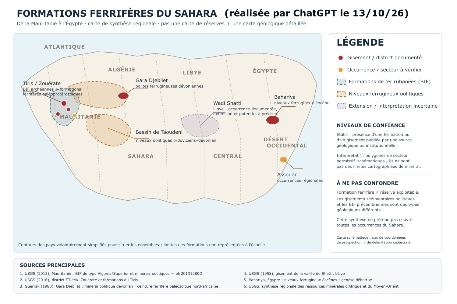
However, in these regions, there are large iron deposits that cause compass needles to deviate see map.
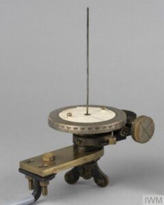
The idea of a sun compass, unaffected by magnetism, therefore became the obvious solution.
Ralph Bagnold’s expertise and ingenuity proved decisive.
The operating principle is very simple: all you need are tables listing the Sun’s azimuth for the desired location and date.
Here are the original instructions for latitude 18° (with explanations on how to adapt them to other latitudes).
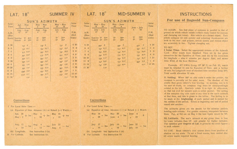
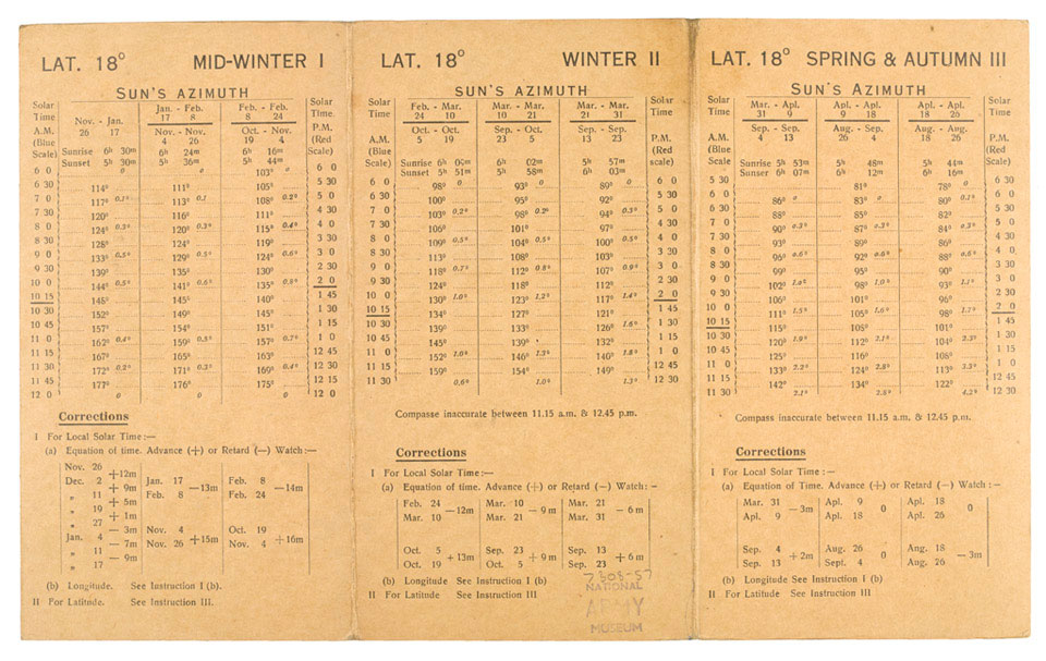

The instruction manual is very short: a single A4 sheet folded in three.
It’s simple and sturdy, just like the LRDG’s equipment.
Image : on January 18, 1943, a patrol of the “Desert Rats,” Detachment “L” of the SAS (Special Air Service), returned from a three-month mission behind enemy lines (Source: IWM E 21337).
Note the Bagnold compass attached to the dashboard, to the right of the driver.
Find more about the LRDG and the SAS here.
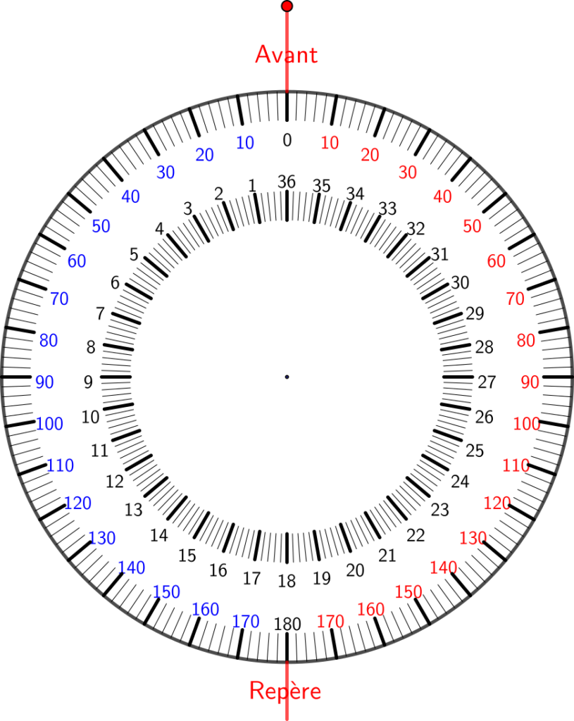
The instrument consists of a simple graduated disc:
- On its surface: from 1 to 36, in increments of ten degrees counterclockwise
- Around its edge: from 0 to 180, twice—once clockwise (in red for the afternoon) and once counterclockwise (in blue, for the morning).
Note: The graduations are marked in 2-degree increments.
Attached to the disc is a gnomon (a straight rod perpendicular to the plane of the disc). Here, it is represented by the point at the center of the disc.
A fixed marker (Repère) on the edge of the disc, such that the marker and the center of the disc are aligned in the direction of the vehicle (labeled “Avant”)
Finally, a screw allows the disc to be rotated relative to the marker.
The Geogebra animation below simulates the use of a Bagnold compass.
The first step is to determine the value corresponding to the Sun’s azimuth for the given latitude, date, and time. To do this, use the brief instructions provided above.
Today, however, we use software…
- AzimutSol: Rotate the disk to align the Sun’s azimuth with the reference line. Blue for the morning, red for the afternoon. You’ll notice that the Sun (orange, on the outer disk) moves.
- AzimutV: Rotate the Jeep in the desired direction. You’ll notice that the vehicle turns, but the Sun’s shadow still points in the direction of the vehicle.
It’s magic, isn’t it?
Play around as much as you like to really understand it…
A few notes:
Solar time
The instruction manual explains how to set the watch to local solar time: it provides the approximate value of the equation of time and the correction to apply based on the estimated longitude. The tables in the instruction manual are therefore given in solar time, which allows them to be perfectly symmetrical. This saves a substantial amount of space: morning hours are read on the left, afternoon hours on the right. This explains the two 180° graduations on the outer disk.
Implications for our app
The slider in the app allows you to vary the Sun’s azimuth from 0° to 360°. However, the outer disk is graduated according to the original instrument (0 to 180° in blue on the left and in red on the right). Consequently, the setting on the scale corresponds to the true azimuth of the Sun only in the morning. Users in the 1940s read the azimuth from the tables above: they displayed the value directly. For a modern user, it’s different: software will give a Sun azimuth greater than 180° in the afternoon. For us, in the afternoon, we’ll rely on the Sun’s position on the outer arc (which is not tied to the vehicle).
Use in the Intertropical Zone
In the intertropical zone, the Sun can be very high in the sky. This is why the gnomon must be very tall, so that the shadow always reaches the graduations. The Sun may even pass north of the gnomon on certain days of the year.
This is why, for certain days, the instruction manual states: “The compass is not accurate between 11:15 a.m. and 12:45 p.m.” (the Sun is too high).
Practical Application
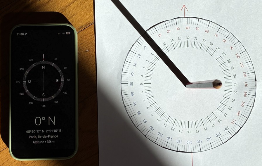
Below is a photo of an experiment conducted in Paris.
On the left is my phone, whose “Compass” app is set to show true north (not magnetic north). You can see that the top of the phone is pointing north (the screen displays 0°N).
On the right is a Bagnold compass I made with the Geogebra app. The gnomon is a pencil placed on the center of the disc. The shadow points to 36, which means the sheet of paper (red arrow) is pointing north.
The sheet of paper and the phone are pointing in the same direction.
In fact, it is 11:30 a.m. (as can be seen in the upper left corner of the phone’s screen). In other words, it is 10:00 a.m. solar time in Paris (give or take 7 minutes). (Make your own Papophoplon to check that). And the Sun’s declination is 142° (see the compass setting in the lower right corner).
It works!