The back of the Papophoplon is only needed if you’re using the instrument somewhere other than the location for which it was designed.
It features a map of France, which shows the additional adjustment required depending on your location.
In practice, find your location on the map and read the adjustment in minutes at the bottom.
That’s it!
If you want to understand why, you can read the following.
Why?
By design, the Papophoplon incorporates the three adjustments between solar time and standard time. However, solar time is local, because solar noon is defined as the moment when the Sun passes exactly over a location’s meridian.
Let’s explain this to understand the back of the Papophoplon.
Here is what the Earth looks like when viewed from above the North Pole (the Greenwich meridian is shown in red):
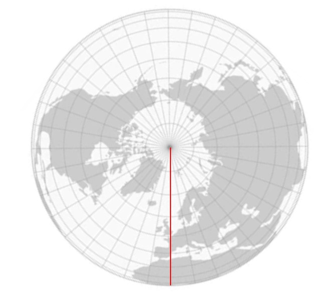
If we focus on France, we get the diagram below:
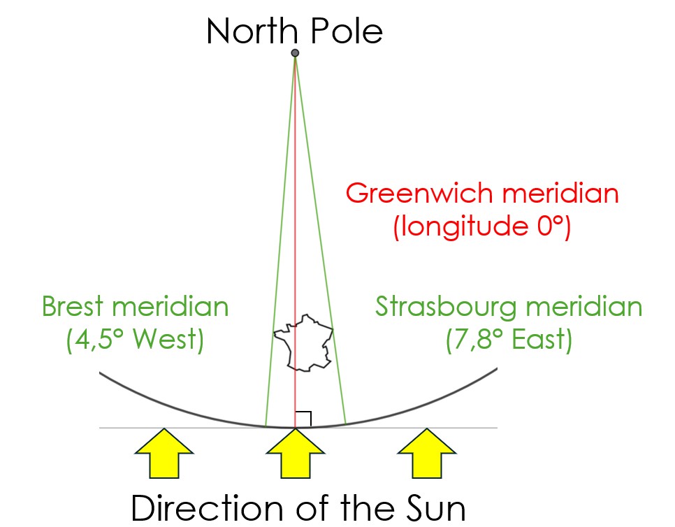
We see that when the Sun is in the south for observers located on the Greenwich meridian, it is not for those on the Brest meridian (where it is not yet noon), nor for those on the Strasbourg meridian (where it is past noon).
This highlights the well-known fact that a difference in longitude is equivalent to a time difference.
Since the Earth completes one rotation in 24 hours (relative to the Sun), we can calculate how much time difference corresponds to one degree of longitude:
Angle |
| Time |
One rotation | -> | 24 hours |
360 degrees | -> | 24 x 60 x 60 = 86,400 seconds |
1 degree | -> | 240 seconds |
We can therefore calculate the time difference between Brest and Strasbourg:
Brest | 4.5° | West |
Strasbourg | 7.8° | East |
Deviation | 12.3° | è 2,952 seconds, or 49.2 minutes |
Conversely, we can calculate the longitude difference corresponding to a 5-minute time difference:
5 × 60 = 300 seconds, divided by 240 = 1.25°
Thus, we can draw a map of France with a meridian every 1.25°, so as to obtain a map of the time difference graduated in 5-minute increments. For example here, a map centered on Paris, which will be printed on the back of a Papophoplon calculated for Paris:
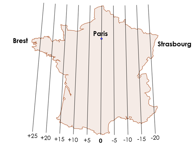
The graduations correspond to the time difference in minutes relative to the location for which the Papophoplon is calculated (here, Paris). We can clearly see the time difference between Brest and Strasbourg of over 49 minutes, or nearly an hour.
In this way, if the Papophoplon is used from a location other than the one for which it was calculated (here, Paris), the additional adjustment needed for the sundial can be read on the map.
Practical Application 1: On the map, we can identify the city of Toulon (the southernmost point of the French Riviera), which lies on the -15-minute meridian.
If you use a Papophoplon calculated for Paris while you are in Toulon, you must subtract 15 minutes from the adjustment found on the indicator.
Practical application 2: On the map, we can identify the Gulf of Morbihan (a small inland sea east of the Quiberon Peninsula in Brittany), which lies on the +20-minute meridian.
If you use a Papophoplon calculated for Paris while you are the Gulf of Morbihan, you must add 20 minutes to the adjustment found on the pointer.
Thus, the Papophoplon becomes universal!